When I sit on the deck drinking my early morning coffee, I watch the birds soaring in the sky. Some are very high, just fast-moving shapes, but others, especially crows and gulls, often fly only a few metres over the houses. I amuse myself by imagining how the neighbourhood must appear viewed through their eyes.
People have always been intrigued by what a bird sees while in flight. Long before anyone successfully rose into the air – in hot-air balloons in the 18th century, or in gliders and aircraft in the late 19th-early 20th centuries – people wanted to know how the landscape or cityscape looked from a so-called bird’s-eye view. Artists were fascinated with this kind of perspective. If they lived in a town, they climbed the highest tower and recorded what unfolded before them. Some must have had incredible patience and endurance, as well as excellent vision, because they produced painstakingly detailed views of all the buildings, down to their doors and windows. We still have such bird’s-eye views of major cities in Europe, from as early as the 16th century. Many of these are so reliable that historians can use them as evidence for their research.
Nowadays we’re spoiled with the number of bird’s-eye views or satellite images that are just a click away on our devices. Who hasn’t used Google Earth, which has been around since the beginning of the 21st century?
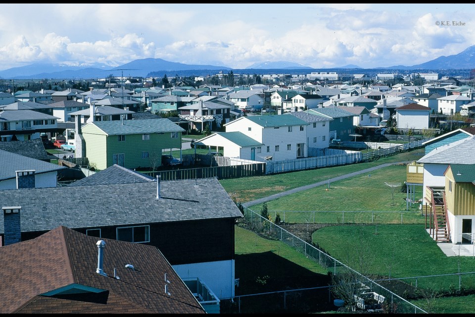
The kind of technology that we take for granted today wasn’t readily available to the ordinary person in the second half of the 20th century, and although there were plenty of aerial photographs, these weren’t easily accessible either. But curiosity about what it would be like to see from a great height wasn’t lacking. And when curiosity is harnessed to imagination and technical skill it could provide the power for the creation of ingenious solutions. This is what’s behind a series of photographs taken by my father in early 1971. They’re bird’s-eye views of a residential neighbourhood in Brighouse Estates, an area circumscribed by Westminster Highway, Gilbert Road, Granville Avenue, and No. 2 Road.
In order to take these bird’s-eye views, my father attached his camera to a long metal rod and went on a tour of the neighbourhood. Nothing obstructed the view. The highrises that today thrust out of Richmond’s ground at every turn hadn’t yet been built. Looking north from Brighouse Estates, a bird – or a camera mounted on a long rod – could see across the Middle Arm of the Fraser River, over the rise of land (University Endowment Lands and south Vancouver) all the way to the North Shore mountains.
What makes these photographs especially magical is that they’re not simply views from the air. They’re not what you’d have seen landing or taking off from YVR. They’re the sort of views that, yes, a low-flying bird would have seen. But also – let your imagination take flight – a low-flier like Supergirl (who’s been filming recently in Vancouver) or, as I prefer, Superman himself.
Sabine Eiche is a local writer and art historian with a PhD from Princeton University. She is passionately involved in preserving the environment and protecting nature. Her columns deal with a broad range of topics and often include the history (etymology) of words in order to shed extra light on the subject.


