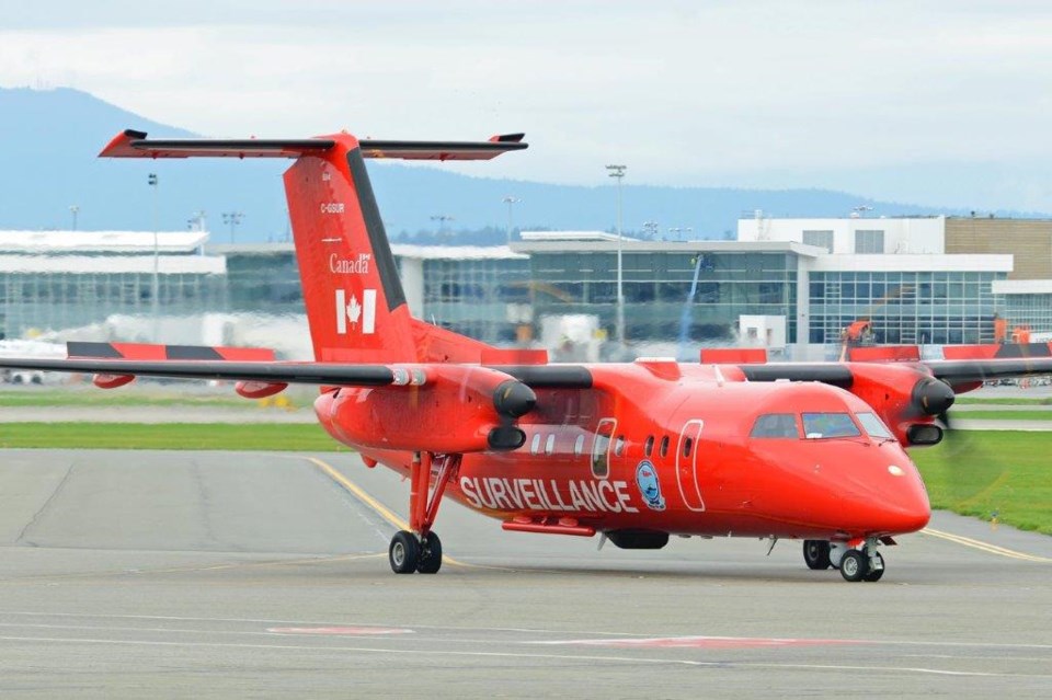
Hundreds of oil spills were detected in B.C. waters over the past two years, thanks to a large red plane based out of Vancouver International Airport.
The cherry-red Dash-8 – part of Transport Canada’s National Aerial Surveillance Program (NASP) – has been transformed from a commercial commuter plane into a maritime patrol aircraft, outfitted with observer stations, a satellite communication system, remote sensor equipment and specialized cameras – all with the goal of preventing marine pollution.
“Most importantly, we have the naked eye from our observers onboard, who are expert witnesses, and they observe, analyze, record and report marine pollution on a daily basis,” said Louis Armstrong, superintendent of intelligence, surveillance and reconnaissance, speaking to the Richmond News from Ottawa.
Last year, data collected by NASP was used to monitor the extent of the pollution in the Nootka Sound area during a clean-up operation to remove around 60 tonnes of heavy fuel oil and diesel from the MV Schiedyk, a 146-metre cargo ship that sank in 1968. The oil posed a significant threat to the marine environment.
The NASP plane also provided situational awareness data to the federal government on the MV Zim Kingston last year and searched for lost containers during routine patrols.
NASP was created in 1991 and is designed to act as a deterrent to marine polluters, said Armstrong, comparing the program to police speed checks that remind drivers to slow down.
He said aerial surveillance is known internationally as “the best method of detecting an oil spill.”
“It’s a very good way of providing information that we see affecting the marine environment to the people who are going to decide the course of action required to combat it.”
There have been cases, Armstrong said, where NASP was on scene directing the coast guard to an oil spill – only the coast guard couldn’t see it, even if they were “right in it.”
It becomes easier to see an oil spill with the naked eye the higher you are, because of how light reflects or refracts off of it, explained Owen Rusticus, regional manager of intelligence, surveillance and reconnaissance, who is based in Richmond.
Sensors aboard the plane also help it to fly at high levels for longer periods of time offshore, Rusticus added, and can detect spills less than a litre in size from a distance of up to 30 miles on each side of the aircraft.
The Dash-8 that can be seen in the skies today has been based in Richmond since 2008, patrolling B.C.’s coast from the Washington to Alaska borders, and up the Fraser River as far as the Mission bridge.
In the spring, when the ice melts and the sea opens to shipping, the plane heads to the western Arctic, setting up base at airports in the Yukon or Northwest Territories to patrol the Mackenzie River and delta, the Yellowknife and Great Slave Lake area, the Beaufort Sea and approaches to the Northwest Passage, said Rusticus.
Other Dash-8’s scour for marine pollution in central and eastern Canada, while an Ottawa-based Dash-7 serves in the North from July to September.
Patrols begin with a pre-flight briefing among the plane’s crew and pilots, and surveillance officers and maintenance engineers to come up with a game plan for the day, based on the weather, various reports received overnight or through the week, and prior patrol routes, said Rusticus.
Once a spill is spotted, he said, its size and location are recorded using the various sensors, photography and video, and reported to Transport Canada, who will take on the investigation from there.
NASP will also report spills to the coast guard, Environment Canada or the province, so they can respond and clean it up, Armstrong said.
On average, the YVR-based plane flies 1,200 hours per year, five to six days a week and for up to seven hours at a time, according to Transport Canada.
From April 2020 to March 2021, the plane flew 1,234 surveillance hours in B.C., flying over 30,623 vessels and detecting 496 pollution incidents during those patrols, while between April 2021 and January of this year, the Dash-8 flew 807 surveillance hours over 17,269 vessels, detecting 152 pollution incidents.
While oil spills are the Dash-8’s primary mission, they aren’t all that the program is tasked with hunting.
Utilizing the specialized equipment on board, NASP also helps to protect the whales that frequent B.C.’s waters – such as humpback whales and orcas – and assist when needed with police investigations, search and rescue missions and humanitarian efforts, such as fires and floods.
Working with the Department of Fisheries and Oceans, Parks Canada, RCMP and Transport Canada, the Richmond-based Dash-8 patrol the waters from the western approaches to the Juan de Fuca Strait up to Campbell River, Rusticus said, ensuring sanctuary zones set up for Southern Resident Killer Whales are respected and that vessels are maintaining a safe distance to marine mammals.
Following last November’s atmospheric river and flooding in southern B.C., the team was tasked with conducting damage assessment of the fibre optic cable lines that ran along some of the damaged highways.
The plane also flew extra patrols over the Fraser River, searching for any impacts from the flooding or debris that might be making its way downriver.
“We built the system (onboard the planes) for oil spills…but it’s evolved so much,” said Armstrong. “It’s been used for so much more.”
Another aircraft is coming online in the fall to help monitor whales across Canada. Drone technology is also being tested to help with the protection of whales, mapping and surveying ice and oil spills in the Arctic. This technology should be deployed next year.


