It’s torn and worn, but what a thrill it gave me when I found it.
I’m talking about a street map of Richmond, published in 1960 by the Board of Trade (present-day Chamber of Commerce).
Inside is a message from the Board of Trade telling us that Richmond “has a population of some 35,000 people, an increase of 6,000 since 1958.” A growth of around 20 per cent in two years sounded remarkable.
I decided to track down some statistics about Richmond’s development.
The earliest record I found is from 1921 – Richmond then had 4,825 residents. There are totals for every decade until 1951, after which they’re given every lustrum (Latin for a five-year span). From 1951 to 1956, the number leapt from 19,186 to 25,978. In 1961, just one year after the population had reached 35,000, it vaulted to 43,323 – around 8,000 new residents, in a single year.
Fifty years later, in 2011, Richmond’s population had risen to 190,473, but the growth from the previous lustrum (2006, when we were at 174,461) was less than 10 per cent.
It came as a surprise to me that the increases in population in the 20th century were much more substantial than those in recent decades.
The 1960 street map gives Richmond’s area as around 38,000 acres.
Today, Richmond’s area is 31,950 acres (129.3 square kilometres). That’s about 6,000 acres less than in 1960 – and yet by 2011, Richmond had over 150,000 more residents than in 1960.
This may be one reason some residents feel there’s a danger of over-densification. After all, Richmond’s capacity is not infinite. It can be stretched only so far before everything bursts like an overblown balloon.
What was Richmond like when the population was a manageable size? In 1959, after living in Burkeville for a few years, my parents moved to Leslie Road.
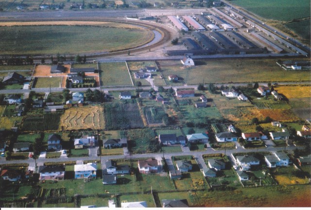
I found an aerial view of our neighbourhood from the early 1960s, showing Leslie Road (foreground), Alexandra Road, Lansdowne Racetrack, and No. 3 Road at right.
It’s a telling picture – houses on spacious lots, large kitchen gardens in backyards, fields in between residential properties. Richmond may have appeared rural, but down No. 3 Road was Brighouse, the commercial district boasting every kind of business.
My parents immigrated in the 1950s, and like so many others, they came not with money but with technical skills.
The post-Second World War economic boom helped enable them to put those skills to work and probably played a role in generating a sense of community.
Lifestyles then were totally different from those of today.
Television was still a novelty and personal computers unheard of – children spent more time playing outdoors, and adults had more time to engage with neighbours.
Rarely did families have more than two cars. There was plenty of house construction even then, but new houses usually harmonized in scale with the older ones in the neighbourhood.
If Richmond had started out as a town of paved driveways and mega-mansions, its inhabitants largely invisible or absent, it’s hard to see how this kind of friendly, vibrant community would have developed.
Sabine Eiche is a writer and art historian (http://members.shaw.ca/seiche/).


