Not all remote regions are disconnected from the rest of the world, according to a Kwantlen Polytechnic University professor.
This is a stereotype Kyle Jackson, who teaches world history at KPU, and history student Lucas Akai set out to tackle through a 3D printed map project with students at the Wilson School of Design in Richmond.
Jackson explained Mizoram, a state in northeastern India that he has been studying for the past 15 years, is “often considered isolated by mainstream Indian society.”
“In Mizoram … one of the most enduring stereotypes is that the people of this upland mountain in the eastern Himalayas are somehow remote, isolated, or cut off from the dynamic processes happening elsewhere, in South Asia and the rest of the world,” said Jackson.
“We wanted to explain that that wasn’t necessarily the case.”
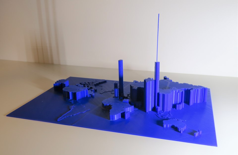
Jackson collected and sourced copies of the regional Mizoram newspaper, Mizo leh Vai Chanchin, spanning three decades from the early 1900s to 1930s, which were then scanned into a software program for the project.
He told the Richmond News the software sorted through more than 1.6 million words of text in both the English and Mizo languages and calculated the number of times each country was mentioned in the newspaper during that time period.
The data was then turned into a 3D printed map and sculpture with the help of Birk Zukowsky, a product design student from Wilson School of Design, and lab coordinator Melanie Bland.
“We were able to quantify the newspaper’s geographic coverage and come up with a shape of the world it had been presenting to its readership,” said Jackson, adding that the sculpture map revealed people in this region of India were “highly interested in reading and writing about wider-world regions.”
“Using the region's first newspaper, we're able to show how local peoples a hundred years ago were not ‘remote’ or cut off from the rest of the world, but rather connected with, and very much concerned about, other peoples the world over.”
When asked why this project is so important, Jackson said the results of the project visually challenge the “longstanding stereotypes” about the history of connections.
It also showed how history and art can collaborate together “to represent the past.”
“This project has showed us how the methods of digital history can allow students to go beyond the traditional 2D research essay and how starting conversations with people beyond the history department can help us change and enrich and be more creative with how we do history.”


