Kyle Graham had been itching to return to Wedgemount Lake since the last time he visited in 2016. Typically, he’s tried to hike the gruelling trail every couple of years.
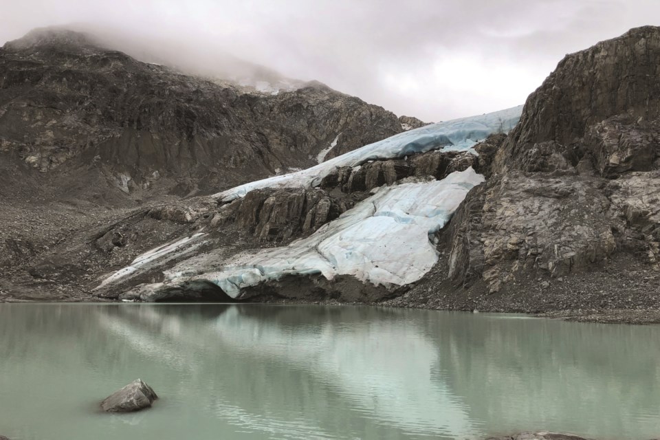
But when he made it over the small ridge of rocks leading past the icy blue lake to Wedgemount Glacier late last month, the scene looked different than Graham remembered.
Where the toe of a sprawling alpine glacier once bordered Tupper Lake—a second lake that first began forming in 2013, in and of itself evidence of a shrinking glacier—instead stood a jagged, rocky cliff partially covered by a thin patch of ice.
“I was almost completely speechless,” said Graham. “I just felt these heavy weights on my chest, of just realizing the magnitude of how much things have changed over five years.”
That feeling was shared by Dave Lyon and his son, Graeme when the pair hiked up the Whistler trail on Saturday, Sept. 11. They had intended to join a crew who were taking a helicopter to the top for an annual monitoring of the glacier, but cloudy weather ultimately cancelled the heli trip.
The father-son duo are an extension of the multi-generational glacier monitoring effort sparked by Karl Ricker and Bill Tupper in 1975, who were often joined by their good friend, Lyon’s father Don, for the annual counts.
Though the Lyons weren’t able to take any official measurements during their trip to Wedgemount Saturday, they managed to snap a few photos that clearly illustrate the considerable amount of ice that’s melted since last September. When the same glacier was last monitored a year ago, researchers found it had receded approximately 30 metres since the previous count in 2019.
But when the most recent measurements are calculated, the numbers will likely paint a far more dramatic picture of ice loss than in 2020 or other recent years, Lyon predicted. That’s partly due to a sizeable portion of ice along the shore of Tupper Lake that, as Lyon observed, has now completely separated from the body of the glacier.
“So the recession this year will be marked from where that rock shelf is,” Lyon explained. “I don’t even want to throw a number out there because I’m completely speculating on how far back [it’s receded,] but it’s substantial.”
Compared to the rate of horizontal recession in recent years, “It has to be quadruple or more, based on last year’s line,” Lyon estimated.
“And what’s really shocking, if you talk to Karl [Ricker]—I mean, when they started this, that glacier was touching [Wedgemount] Lake.”
Hot summer contributing to already accelerating melt rates, says glaciologist
This accelerated glacial recession is not unique to Whistler, explained University of British Columbia (UBC) professor and glaciologist Michele Koppes. She and her fellow researchers have similarly observed higher rates of ice loss in glaciers across the province, including on the Bridge Glacier along the Lillooet Icefield, as well as on the Helm Glacier in Whistler and the Place Glacier near Birken. The Geological Survey of Canada has been monitoring the latter two sites as indices of glacial melt in the region, measuring both the glaciers’ retreat and residual water flow rates since the 1970s.
“What we’ve seen is, there’s been steady retreat through the ‘80s and ‘90s, and then starting in the early 2000s, we’ve just seen an accelerated amount of retreat,” Koppes said.
While she acknowledged researchers are still awaiting final numbers from this year as the melt season continues, it’s “absolutely” possible to attribute the higher melt rate with the unprecedented temperatures the West Coast experienced earlier in the summer.
“Glaciers are kind of a storehouse of climate,” Koppes said. In picturing B.C.’s glaciers as water towers, this summer’s string of heat waves contributed to decreasing each tank’s supply, she explained: “All of these glaciers are shrinking pretty dramatically, and it has to do with the heat that happened early in the melt season, which removed all the snow on the surface of the glaciers, and then it started melting ice.”
Because the heat waves and resulting melt events came on suddenly, new water channels also opened up underneath glaciers, Koppes continued. “So the outlet streams have been higher than we’ve ever recorded before as well, and they’re kind of drawing water from underneath the glaciers faster than they were before,” she said.
For example, when Koppes’ team returned to the Lillooet Icefield this summer for the first time since they last visited in 2016, they found a glacier that “has both retreated over a kilometre, which is a huge amount, and it has lowered by 50, 60 metres, which is also an enormous amount,” she said.
Even more striking? In the decades spanning from the 1970s to around 2012, the glacier retreated a total of about four kilometres, said Koppes. In just the past nine years, it’s already retreated more than a kilometre further.
Witnessing this ice loss firsthand brings about “a lot of grief,” Koppes said.
“Grief that these systems are changing so dramatically, and that we’re losing these beautiful places. And it’s just kind of awe at the system—at how much humans, who are just one species among millions of species on Earth, can have such a dramatic impact on these icy places. Places that we don’t really hang out in. We don’t live right there, but we can still have this effect on these places—dramatic effects—from our behaviours far away.”
As B.C.’s ice continues to melt, the province could eventually see those dramatic effects passed along to communities downstream. The province currently depends on glacier runoff for purposes like agriculture irrigation, hydroelectricity, and regulating aquatic habitats with the cool, fresh water they need.
In sticking with the water-tower analogy, glaciers “store the water in the winter and release it in the summer melting months, which is normally the time that we don’t have a lot of rainfall—and when we have a lot of wildfire,” she explained. “As these glaciers are shrinking, they’re delivering water earlier in the season … they’re less reliable, and there [are] bigger floods that are happening that influence infrastructure.” Lost glacial mass also means faster-flowing water sources, more erosion and more sediment in local waterways, Koppes added.
With a 2015 UBC study finding that British Columbia and Alberta could lose around 70 per cent of glacier ice by the end of the 21st century, “The thing that would be most important to consider at this point is how we adapt to these changes. How do we create resilience in our infrastructure so that when we have more floods, and more sediment downstream that we can respond to that effectively?” Koppes said.
'This is our own backyard'
Following Graham’s hike to Wedgemount Lake this August, the Whistlerite compared the photo he took that day to one he shot from the same angle five years ago. The stark difference in the images prompted him to share the photos with the tens of thousands of members of the Whistler Summer Facebook group, sparking not only hundreds of reactions and comments but a conversation about what can be done to better protect the environment as we reckon with the local impacts of climate change.
“Our minds can interpret things a certain way, of how the world is changing, but getting a real-life perspective through a photograph of before and after of what’s changing in our own backyard can be really eye-opening. Whenever I see a before-and-after of glaciers in Greenland or something, it’s still impactful, but I feel like it’s a little bit more impactful when you see it in your own backyard. That is why I was wanting to showcase it,” said Graham.
“This is what’s happening here.”
.jpg;w=120;h=80;mode=crop)

