A recent review of future flood scenarios by the Fraser Basin Council shows Richmond and municipalities upstream are extremely vulnerable, as sea levels continue to rise, glacier runoff becomes more pronounced and the potential for more extreme storms increases.
It’s hardly news to Richmond residents, who meander around town below sea level during high tide.
What the study does reveal, however, is a new estimate of the devastation that could occur unless a comprehensive flood management plan is put in place.
The council estimates a major flood would result in economic losses of $20-30 billion, making it the costliest natural disaster in Canadian history.
Flood risks are increasing as sea levels rise and spring freshets, or run-offs, become more intense, noted the council’s report, released Monday.
“The research makes one thing clear: under climate change, major floods in the Lower Mainland are expected to increase in magnitude and frequency,” noted the report.
The council’s report is intended to draw a picture of various potential flood scenarios. It has since received funding from the provincial government to develop a “flood action plan” by 2018 that will incorporate various stakeholders, such as agriculture, business, the port, all levels of government and First Nations.
“There’s a pressing need for climate change adaptation in how we plan communities, and the diking system is no exception.” said the council’s chair (and former MLA) Colin Hansen in an online statement.
“We have to approach flood protection to address the new reality.”
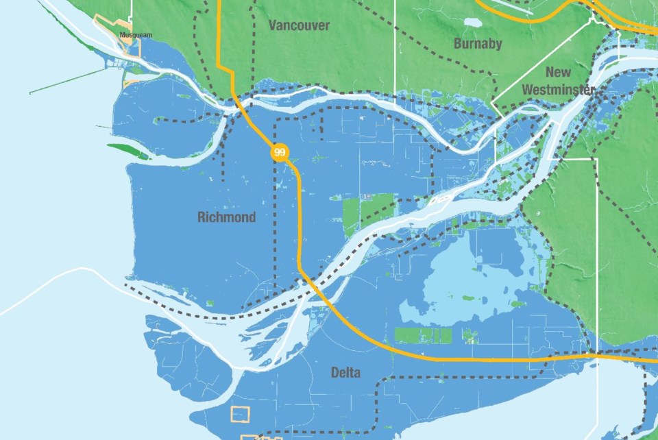
The council’s study noted that in all four scenarios that charted a one-in-500-year flood event, Richmond would be nearly entirely flooded. Scenarios looked at coastal floods and Fraser River floods, either at present day or in 2100, when local sea levels are expected to be one metre above where they are now.
And while it was determined the City of Richmond administers its dykes and pumping systems well, its dykes are still vulnerable in the event of an earthquake.
Among the concerns is sand that is likely to liquefy, resulting in lateral spreading. Another concern is roads and buildings encroaching on some parts of the dyke.
The City of Richmond typically invests tens of millions of dollars each year on pump station and dyke upgrades. It has even leveraged some development sites to raise adjacent dykes above current provincial standards.
In Steveston, the city eventually plans to build a dyke along Shady Island and build a sea gate for Steveston Harbour. As a result of sea level rise and river dredging, the city will also likely need to build sea berms, or breakwaters, just beyond Sturgeon Bank, to keep the West Dyke effective in storm surges.
The council’s report was generally light on specific details for Richmond, instead focusing on the impact to the Fraser River estuary as a whole.
The worse case scenario would be a devastating river flood caused by high tides and record setting spring freshet, in addition to sea level rise. Such a flood would cause an estimated $18.4 billion in building-related losses (products, personal contents, wage losses), $7.7 billion in cargo shipment interruptions, $5 billion in infrastructure losses and $1.6 billion in agricultural losses.
Those figures do not include many other losses, such as clean-up costs; it’s estimated a major flood could produce 1.34 million tons of debris and wastewater could flow freely.
Nothing would escape damage in Richmond, including its hospital, numerous power substations, highways, the Canada Line and schools. Vancouver International Airport would be rendered useless.
The council is recommending all levels of government prioritize dyke upgrades and create a dedicated, multi-year funding program.


