An adjacent pedestrian bridge that links Lulu Island to Sea Island may ultimately compliment a planned riverfront park east of the Dinsmore Bridge. From there, cyclists and pedestrians may head to Iona Beach Regional Park and camp under the stars. Or they may just enjoy some time spent on a floating park.
These are just some of the ideas being floated by park planners in the city as a regional riverfront trail system continues to be developed.
According to a report to the parks committee this week, the Experience the Fraser Concept Plan, which aims to connect trails along the Fraser River from Richmond all the way to Hope and the Fraser Canyon, will expand to the north and middle arms of the Fraser River. The plan incorporates the 642 kilometre Canyon to Coast Trail, which includes connections to Howe Sound and Washington State. Trails along the river are referred to as the Recreational Blueway.
The goal of this inter-regional network of Blueway trails is to "showcase the rich recreational, cultural and natural heritage of the Fraser River." This will allow greater regional access to major recreational destinations in the city such as Steveston, Riverport, Richmond City Centre, Terra Nova Rural Park and Iona.
The trails and pathways on each side of the middle and north arms will add 92 kilometres to the trail network, which is only about 50 per cent complete to date. There's no timeline put forth for completion at the moment as the plan is more of a piecemeal project and gaps in the system will be filled over time. There is also no estimated cost as many elements of Experience the Fraser are incorporated into other projects, namely bridges and official community plans.
Crossing the river is an integral part of the trail network. The planned bridge at the George Massey Tunnel as well as a new Pattullo Bridge are likely to feature pedestrian and cycling paths. There is also a pedestrian/cyclist bridge being planned between New Westminster and Queensborough. Meanwhile, repurposing a rail bridge between Burnaby and Richmond for pedestrians and cyclists is also a possibility. Of course, the Canada Line Bridge has already been proven to successfully funnel cyclists between Richmond and Vancouver.
Meanwhile, the report, from senior parks manager Mike Redpath, notes a pedestrian bridge on the middle arm, connecting West Cambie and the Olympic Oval neighbourhoods to Sea Island is planned over the long term. If it's not a bridge people fancy, it's believed with more development there may be opportunities to introduce a passenger ferry service like the ones found in Vancouver's False Creek.
All of these trails will feature opportunities for recreation. For instance, as noted, camping has been suggested at Iona. Also, it is hoped the trail system will offer more boat and/or canoe and kayak launches. And in Richmond, where development along the north arm is occurring rapidly (Oval Village, Parc Riviera, River Rock Casino and Resort) there will be more opportunities for riverfront plazas.
One of the biggest obstacles to overcome is how the trails can connect with one another through industrial land. Metro Vancouver planners are working with industry to develop design guidelines for where trails intersect with such areas. For safety reasons, planners must also tread lightly when planning water activities in certain low-traffic areas (like in front of the UBC Boathouse).
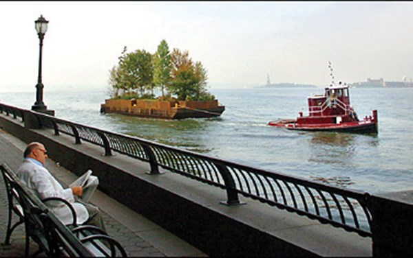
Planning for recreational activities may even require floating amenity barges in the future. Redpath's report includes photos of a floating park in New York City (an art project, in fact) as well as a floating restaurant, pulled by a tugboat. It's thought municipalities can share in the costs of these barges, which can then move from one city to another as they host special waterfront community events.
@WestcoastWood


