
It appears today (June 27) may be the peak of the heat dome across the Tri-Cities, but it likely will stay for several more days.
Environment Canada is predicting a high of 39 C but with humidity, it could feel like 45 C in places like Coquitlam, Port Coquitlam and Port Moody.
According to the national service's forecast, today may be the hottest of the warning — which took effect June 23 for Metro Vancouver in what meteorologists called a "dangerous long-duration heatwave."
Temperatures are expected to slowly welt out of the 30s and 40s and back to normal seasonal numbers hovering around the mid-20s.
Thus far, no official records have been broken or have been made public by Environment Canada, but experts are continuing to preach vigilance in staying as cool as possible as extreme heat is a public health threat.
"The duration of this heatwave is concerning as there is little relief at night with elevated overnight temperatures," the agency said.
"Watch for the symptoms of heat illness: dizziness/fainting; nausea/vomiting; rapid breathing and heartbeat; extreme thirst; decreased urination with unusually dark urine. Outdoor workers should take regularly scheduled breaks in a cool place."
You can review the seven-day forecast in the graphic below (subject to change).
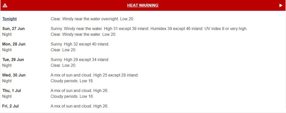 Environment Canada's forecast starting June 27, 2021. The heat wave is expected to last in the Tri-Cities until "at least Wednesday (June 30).". By Environment Canada
Additionally, as of 3:45 p.m. on Saturday (June 26), an air quality advisory is issued for Metro Vancouver communities as high concentrations of "ground-level ozone" are expected to persist during the heat warning.
The release from the federation says ground-level ozone is usually highest from mid-afternoon to early evening and suggests avoiding strenuous outdoor activities.
It says exposure is particularly concerning for people with underlying health conditions and respiratory infections, such as COVID-19, as well as pregnant women, children, outdoor workers, older adults and unhoused people.
IN CASE YOU MISSED IT
If you're scratching your head (or hat if you're outside while reading this) as to why the Tri-Cities (and most of B.C.) is in a heatwave, it's because we didn't get as much precipitation in May as it normally would.
In fact, there were record droughts in the interior and south coast neighbourhoods, something that's also been building across much of the North American west for months now.
A heat dome forms when the jet stream migrates north, allowing an intense, high-pressure system to create a cap over hot ocean air. When that air descends, it warms.
By trapping heat at the surface, the "dome" creates a feedback effect leading to sweltering conditions from day to night.
Faron Anslow leads climate analysis and monitoring at the Victoria-based Pacific Climate Impact Consortium.
He says climate scientists are not quite at the point where they can pin a single extreme weather event to climate change on the fly, but believes all the telltale signs are there.
“What we can say is that these heatwaves are consistent with climate change. They line up with what we expect from climate models,” he says.
A European heatwave that consumed the continent and shattered temperature records in 2019 was found to have been five times more likely to occur because of climate change.
Anslow says he wouldn’t be surprised if data revealed a similar connection for B.C.’s upcoming heatwave.
TIPS TO BEAT THE HEAT
GO SOMEWHERE COOL
- Cool down in an air-conditioned location such as a store, shopping mall, movie theatre or library
- Visit a spray park or book a visit at one of our four outdoor pools
- COVID-19 restrictions are in place, pre-registration is required via the city of Port Coquitlam's website.
Protect yourself, your pets and your loved ones by:
- Avoiding sun exposure
- Go out when it’s cooler, stay in the shade and cover your head and face with a wide-brimmed breathable hat or umbrella; use sunscreen that is SPF 30 or higher
- Dressing in lightweight, light-coloured and loose-fitting clothing made of breathable fabric
- Not leaving people or pets in your care inside a parked vehicle or in direct sunlight
- Checking frequently on family members, neighbours and friends who are elderly or chronically ill to make sure they are cool and hydrated
STAYING COOL AT HOME
- Taking a cool shower or bath
- Preparing meals that don’t need to be cooked in the oven, such as fresh meals that don’t require cooking
- Avoiding caffeine or alcoholic beverages as both can act as diuretics and promote dehydration
- Blocking out the sun by opening awnings, and closing curtains or blinds during the day
- Drinking plenty of water to stay hydrated; use a cool cloth or consider using a spray bottle filled with cold water for refreshing spritzes throughout the day
- Heading to a room in the basement for slightly cooler temperatures
- Sitting in the path of a fan that is aimed at an open cooler or a pan filled with ice
Also, don't leave pets or people inside parked vehicles!
- with files from Diane Strandberg, Tri-City News, Stefan Labbé, Glacier Media, and The Canadian Press


