The City of Richmond has chosen the name Lulu Island Park for its future City Centre park along the Fraser River’s middle arm.
Mayor Malcolm Brodie announced the name at a council meeting July 24.
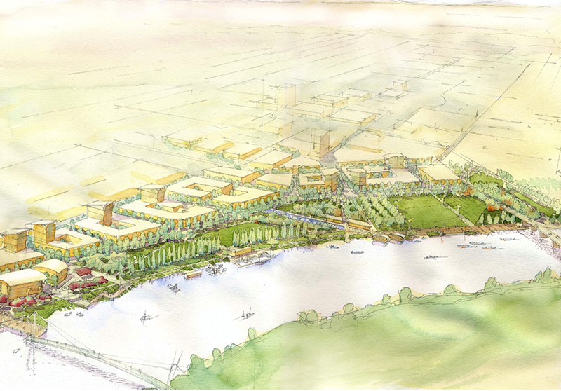
Lulu Island Park will begin immediately north of the Dinsmore Bridge and extend to near Cambie Road, along the river’s dyke trail. The city is in the tail-end of purchasing 28 acres of light industrial land and will demolish the existing buildings to make way for the likes of a large festival field, a native forest and wetland and an observation hill for rowing and Dragon Boat competitions.
Moving people to and from the park will be a planned, $11 million, four-lane arterial road, River Parkway, which will replace River Road north of the Dinsmore Bridge and extend to Capstan Way.
As of 2015, it is expected the park will be finished by 2028.
Either end of Lulu Island Park will be complemented by an expanded linear park along the dyke known as Middle Arm Waterfront Park. The parks will form The Middle Arm Greenway — as it will be known — which will connect the largely residential zones of the Terra Nova, Oval and Minoru neighbourhoods to the waterfront residential-maritime “mews” of Capstan Village, as well as the planned business-oriented Bridgeport Village that plans to feature an international trade centre (under construction), hotels and an “entertainment” zone.
Lulu Island Park could also one day be home to a pedestrian bridge to Sea Island. There are even ideas floated around that would see a passenger ferry system on the river.
For more details on the Lulu Island Park, see this story:


